Panda Helper iOS
VIP Version Free Version Jailbroken Version- Panda Helper >
- iOS Apps >
- National Hurricane Center Data
National Hurricane Center Data
- Sizes: 17.8 MB
- Version: 1.1.18
- Update: 2018-10-06
National Hurricane Center Data Description
MAIN FEATURES INCLUDE:
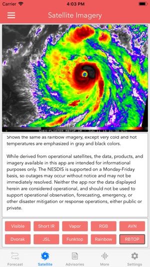
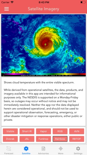
* NHC GOES-16 Satellite Imagery
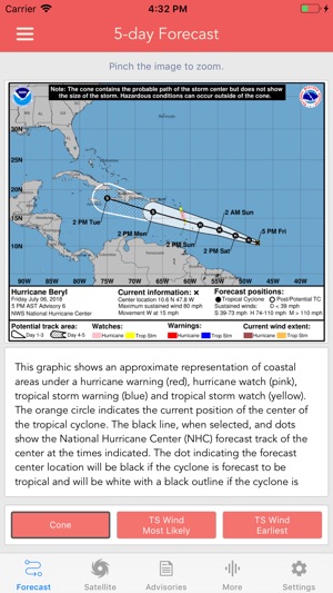
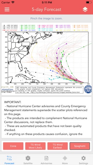
* 5-day Hurricane Forecast / Tracker
* Spaghetti Models!
* 5-day Tropical Storm Outlook (Pacific)
* 5-day Tropical Storm Outlook (Atlantic)
* 5-day Tropical Storm Outlook (Central Pacific)
* 2-week Tropical Storm Outlook (Global)
* NWS Tropical Weather Discussion
* Storm Specific Forecast & Public Advisories
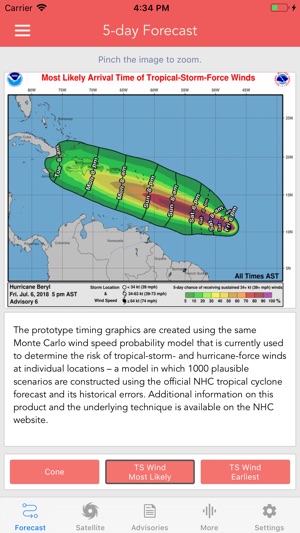
* Wind History, Rainfall Forecast & Flash Flood Risk Graphics
* New Storm Push Notifications
By far the fastest, most convenient way to access National Hurricane Center data. The app displays detailed satellite imagery animations, allowing you to track the storm using the most recent observations.
More satellite filter details below:
-- Band 2 --
0.64 µm - 'Red' Band - 0.5 km resolution - Visible band 2 is in the red portion of the spectrum and has the highest resolution of any ABI band at 0.5 km, and for that reason is the primary visible band. It is used primarily to monitor the evolution of clouds throughout the daylight hours.
-- Band 4 --
1.37 µm - 'Cirrus' Band - 2 km resolution - Band 4 will detect very thin cirrus clouds during the day. This band is centered in a strong water vapor absorption spectral region. It does not routinely sense the lower troposphere, where there is substantial water vapor, and thus provides excellent daytime sensitivity to high, very thin cirrus under most circumstances.
-- Band 5 --
1.6 µm - 'Snow/Ice' Band - 1 km resolution - During the day band 5 can be used to differentiate ice clouds and snow (relatively dark) from liquid water clouds (relatively bright), such as fog and stratus. It can also detect very hot fires both day and night.
-- Band 7 --
3.9 µm - 'Shortwave Window' Band - 2 km resolution - Band 7 has a variety of applications, including fire detection, cloud particle size retrievals, and differentiating between liquid water and ice clouds. Fire hot spots will show up as relatively small dark gray to black pixels. GOES-16 band 7 corresponds approximately to the old GOES-13 infrared channel.
-- Band 8 / 9 / 10 --
6.2 µm - 'Water Vapor' Bands - Band 8 will be used for upper-level tropospheric water vapor tracking, jet stream identification, hurricane track forecasting, mid-latitude storm forecasting, severe weather analysis, upper mid-level moisture estimation (for legacy vertical moisture profiles) and turbulence detection. The imager on GOES-16 features three mid-level water vapor bands instead of the single water vapor band on the GOES-13 Imager. The single water vapor band on GOES-13 contained a mixture of water vapor features over many levels of the troposphere, but GOES-16 enables us to focus on water vapor in the upper troposphere (band 8), the middle troposphere (band 9), or the lower troposphere (band 10).
-- Band 13 --
10.3 µm - 'Clean' Longwave IR Window Band - Band 13 at 10.3 µm is an infrared window, meaning it is not strongly affected by atmospheric water vapor. This channel is useful for detecting clouds all times of day and night and is particularly useful in retrievals of cloud top height.
-- Band 14 --
11.2 µm - IR Longwave Window Band - the traditional longwave infrared window band, is used to diagnose discrete clouds and organized features for general weather forecasting, analysis, and broadcasting applications. Observations from this IR window channel characterize atmospheric processes associated with extratropical cyclones and also in single thunderstorms and convective complexes.
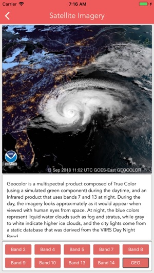
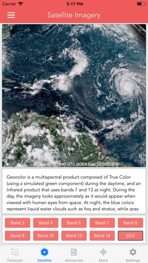
-- GEOCOLOR Band --
Geocolor is a multispectral product composed of True Color during the daytime, and an Infrared product that uses bands 7 and 13 at night. During the day, the imagery looks approximately as it would appear when viewed with human eyes from space. At night, the blue colors represent liquid water clouds such as fog and stratus, while gray to white indicate higher ice clouds, and the city lights come from a static database.
National Hurricane Center Data Guide
Download the most comprehensive Hurricane Tracker app for iOS.
MAIN FEATURES INCLUDE:
+ GOES Satellite Imagery Animations
+ National Hurricane Center Products
+ National Weather Service Alerts
+ Weather Prediction Center Graphics
+ Tropical Weather Push Notifications
+ Satellite Imagery Home Screen Widget
+ Spaghetti Models
GRAPHICAL PRODUCTS INCLUDE:
Forecast Graphics
- Spaghetti Models
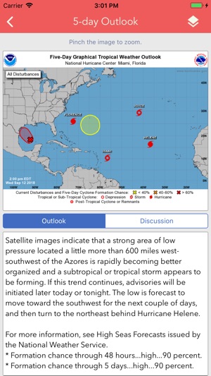
- 7-Day Tropical Weather Outlook
- 3-Day Excessive Rainfall Outlook
- 7-Day Quantitative Precipitation Forecast
Storm Specific Graphics
- Key Messages
- Cone Track Forecast
- Tropical Storm Wind (Most Likely)
- Tropical Storm Wind (Earliest)
- Hurricane Wind Probability
- Surface Wind Field
- Surface Wind Analysis
- Wind / Track History
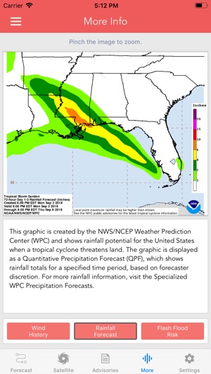
- Rainfall Forecast
- Flash Flood Risk
Local Storm Threat Graphics
- Flooding Rain Threat
- Wind Threat
- Surge Threat
- Tornado Threat
- Rainfall Totals
- Wind Warnings
Note: Local threat graphics are typically not available until shortly before storm landfall.
TEXT PRODUCTS INCLUDE:
- Tropical Weather Outlook
- Forecast Advisories
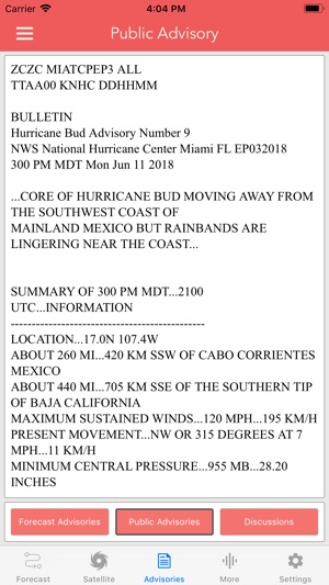
- Public Advisories
- Forecast Office Discussion
- Local Statement (HLS)
- Local Warnings (TCV)
- Tropical Discussion
- Wind Analysis
WEATHER MAP OVERLAYS INCLUDE:
- Hurricane Track & Intensity
- Potential Storm Surge Flooding
- NASA Sea Surface Temperature
- NOAA Weather Radar
GOES SATELLITE IMAGERY INCLUDES:
Fifteen (15) Satellite Imagery Filters
- Visible (Band 2)
- Near IR (Bands 4 & 5)
- Infrared (Bands 7, 8, 9, 10, 13, 14 & 16)
- Nighttime Microphysics
- Day Cloud Phase
- True Color
- Air Mass
- Sandwich
APPLE WATCH APP INCLUDES:
- View wind speed & intensity updates every 30 minutes
- View the latest satellite imagery
- Choose from a variety of Watch Complications
-- PRO SUBSCRIPTION FEATURES --
Full Screen, High Resolution Satellite Imagery:
- Latest Image
- Animated Loop
- Mesoscale: Near Real-time Imagery
- Geostationary Lightning Mapper (GLM)
Mesoscale imagery typically has 1-minute temporal resolution, but is not always available for each storm.
16-day Weather Forecast Models:
- Global Forecast System (GFS)
- Global Ensemble Forecast System (GEFS)
- North American Ensemble (NAEFS)
Weather Simulation Forecast Models:
- Hi-Res Rapid Refresh (HRRR)
- Hi-Res Ensemble Forecast (HREF)
- North American Mesoscale (NAM)
- Hi-Res North American Mesoscale
(NAM-HIRES)
- High Resolution Window
(HRW-FV3, HRW-ARW, HRW-ARW2)
- WaveWatch III (WW3)
- European Centre for Medium-Range Weather
(ECMWF)
HMON & HWRF Hurricane Forecast Models
Experimental Forecast Animations:
- Simulated Radar 2km
- Surface Pressure, Wind
- 200mb Temp, Ht, Wind
- 700mb RH, Ht, Wind
- 850mb Vort, Wind, Thick
Model Analysis & Guidance Animations:
- 6h Total Precipitation
- 10m Wind
- 200mb Vort, Wind, Ht
- 500mb Relative Humidity
- 700mb Vort, Wind, Ht
- 850mb Vort, Wind, Ht
Static Forecast Products
- Track*
- Intensity*
- Pressure*
- Rain
- Wind
* Track, Intensity and Pressure graphics include spaghetti plots when available. Models included in spaghetti graphics include: HWRF, HMON, CTCX, AVNO, SHF5 & OFCL.
NCEP / EMC Cyclogenesis Tracking Products
- 16-day Storm Forecast Tracks
- 21-day Global Tropics Hazards Outlook
- 35-day Probability of Formation
CIMSS Tropical Cyclone Products
- Wind Vorticity & Shear Analysis
- Steering Layer Analysis
- Morphed Integrated Microwave Imagery
- Advanced Dvorak Technique (ADTV9.0)
ADT Includes imagery, wind radii estimates & trends
Interactive Hurricane Tracker Map
- Track & Intensity Forecast
- Preliminary Best Track Analysis
TERMS & CONDITIONS
https://lwbrandsllc.com/hurricane-app-terms-conditions/
--
In total, there are now over 100+ hurricane / weather tracking products to help you stay informed during hurricane season.
National Hurricane Center Data Information
Name National Hurricane Center Data
Category Weather
Developer LW Brands, LLC
Version 1.1.18
Update 2018-10-06
Languages English, French
Size 17.8 MB
Compatibility Requires iOS 9.0 or later. Compatible with iPhone, iPad, and iPod touch.
Other Original Version
National Hurricane Center Data Screenshot
Rating
Tap to Rate
Panda Helper
App Market


Latest News
8 Back Office Outsourcing Companies Helping Businesses Manage Daily Tasks The Best Translator English to Spanish 7 Best Artificial Intelligence Programs for Future Innovators The Role of Mobile Apps in Improving Student Performance Mobile Game Testing Services: Key Benefits for Developers in 2025 How Proxy Servers and VPNs Shape the Battle for Online Anonymity and SEO Integrity