Trending Searches

    History

      Clear All
      i-Boating: USA Marine Charts

      i-Boating: USA Marine Charts

      • Sizes: 61.49MB
      • Version: 107.0.0
      • Update: 2021-05-27
      Install by Apple Store

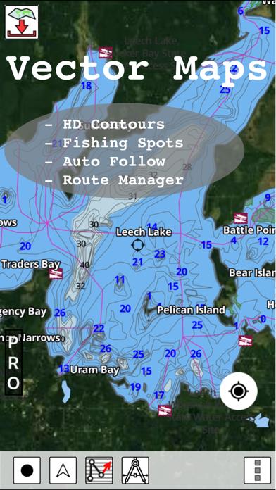
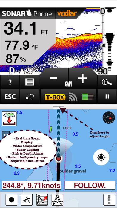
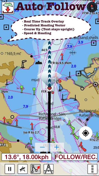
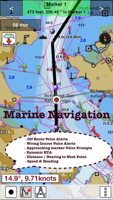
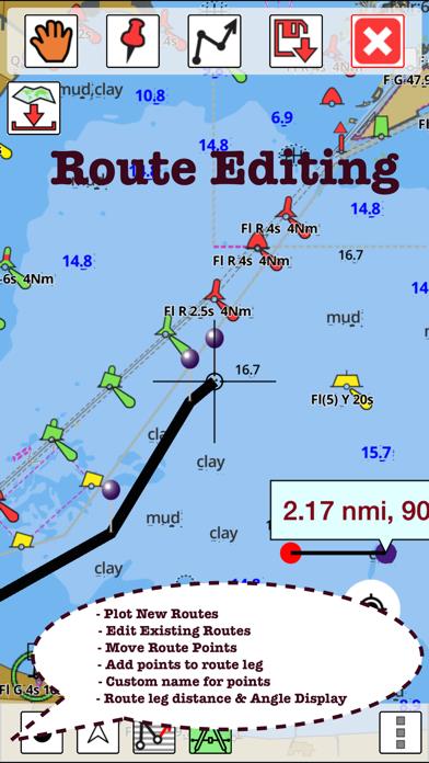
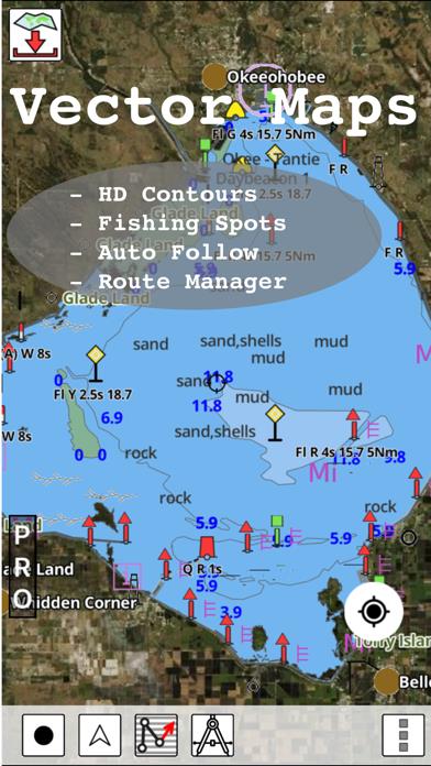
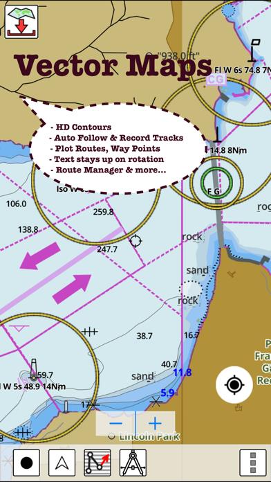
      i-Boating: USA Marine Charts Description

      This App offers access to NOAA marine vector charts, freshwater lake maps, USACE inland river maps (HD/1ft/3ft bathymetry included where available). First marine GPS app to have route assistance with Voice Prompts for marine navigation. You can create new boating routes or import existing GPX/KML routes. It supports Nautical Charts course up orientation. Includes Tide & Currents prediction. ►FEATURES √ Beautiful and detailed Hardware/GPU accelerated vector charts (text stays upright on rotation) √ Long press to query the details of Marine object (Buoy, Lights, Obstruction etc). √ Customizable depth(Ft/Fathom/Meter) and distance units (km/mi/NM) √ Customizable Shallow Depth. √ Record tracks, Autofollow with real-time track overlay & predicted path vector. √ Voice Prompts for marine navigation (requires GPS ) √ 1ft / 3ft depth contour maps for anglers for selected lake maps. √ Supports GPX/KML for boating route editing/import. √ Tide & Currents prediction. √ Seamless chart quilting of marine charts √ Enter or import Waypoints. ► MAPS The maps include coverage of all NOAA marine vector charts (ENC), USACE inland river maps, and freshwater lake maps for more than 7K lakes. The charts include HD/1ft/3ft bathymetry where available. The app also includes NOAA raster charts for some areas where NOAA ENC coverage is not available. It includes unlimited updates for 1 year. ►ROUTE MANAGEMENT / TRIP PLANNING √ Create New Route/Edit Existing Routes √ Move Points √ Add points to an existing route leg √ Delete / Rename points √ Import GPX, KML & KMZ files √ Plot/Edit Routes √ Enter Waypoints √ Share/Export Routes, Tracks & Markers √ Reverse Routes ►GPS FEATURES √ Auto Follow * Real Time Track Overlay * Predicted Path Vector * Course Up (Text stays upright) * Speed & Heading √ Route Assistance With Voice Prompts * Prompts when approaching a boating route marker * Continous distance and ETA updates * Alerts when sailing/boating off route * Alerts when boating in wrong direction √ Record Tracks ►TIDE & CURRENTS * For US, Canada, UK, Germany & New Zealand * High/Low Tides * Tidal Current Prediction * Active Current Stations ► SHARING * Share tracks/routes/markers on Facebook & Twitter * Export tracks/routes/markers as compressed GPX files. Sample Nautical Charts (please visit http://gpsnauticalcharts.com/main/folio-catalog-nautical-charts-app for complete list) SUGARLOAF KEY-KEY WEST PORT RICHEY TAMPA BAY - CLEARWATER HBR EAST BAY-WEST BAY FLORIDA ST JOSEPH, ST ANDREW BAYS INTRACOASTAL WATERWAY MATECUMBE-GRASSY KEY CHESAPEAKE BAY CAPE CHARLES-NORFOLK HARBOR ANCLOTE KEYS-CRYSTAL RIVER ST JOSEPH SOUND MIAMI HARBOR Minnesota lakes - Kabetogama, Minnetonka, Waconia,Leech,Mille Lacs Lake Keowee,Jocassee,Hartwell,Greenwood,Lake Murray Mark Twain,Ozarks,Table Rock Lake St. Clair Lake Kentucky KEY WEST-THE MISSISSIPPI RIVER SAN PEDRO CHANNEL LAKE MICHIGAN STONY LAKE-POINT BETSIE APALACHICOLA BAY-CAPE SAN BLAS EAST CAPE-MORMON KEY CAPE HENLOPEN-INDIAN RIVER INLET CHESAPEAKE BAY CAPE HENRY-THIMBLE SHOAL LIGHT DULUTH-SUPERIOR HARBOR MONHEGAN ISLAND-CAPE ELIZABETH LAKE ONTARIO - CLAYTON-FALSE DUCKS ISL Lake Winnipesaukee SAN FRANCISCO ENTRANCE MIAMI-MARATHON, FLORIDA BAY CAPE MAY-FENWICK ISLAND MISSISSIPPI RIVER-GALVESTON CAPE CANAVERAL-KEY WEST DELAWARE RIVER WILMINGTON-PHILADELPHIA FLORIDA KEYS SOMBRERO KEY-SAND KEY SAN PABLO BAY RAINY LAKE BIG ISLAND MINN-OAKPOINT ISL ONT INTRACOASTAL WATERWAY - BISCAYNE BAY EVERGLADES NTL PARK - SHARK RVR-LOSTMANS RVR MIAMI-MARATHON & FLORIDA BAY BLACKBURN BAY LAKE HURON LAKE TAHOE STRAITS OF MACKINAC NORFOLK HARBOR & ELIZABETH RIVER SAN DIEGO-SANTA ROSA ISLAND DELAWARE BAY CHOPTANK RIVER CAMBRIDGE-GREENSBORO FORT LAUDERDALE PORT EVERGLADES ST SIMONS SOUND-TOLOMATO RIVER CHESAPEAKE DELAWARE CANAL PLEASE NOTE: Continued use of GPS running in the background can dramatically decrease battery life.

      i-Boating: USA Marine Charts Information

      Name i-Boating: USA Marine Charts

      Category Navigation

      Developer Bist LLC

      Version 107.0.0

      Update 2021-05-27

      Languages NL,EN,FI,FR,DE,NB,RU,SV

      Size 61.49MB

      Compatibility Requires iOS 8.0 or later. Compatible with iPhone, iPad, and iPod touch.

      Other Original Version

      i-Boating: USA Marine Charts Screenshot

      i-Boating: USA Marine Charts
      i-Boating: USA Marine Charts
      i-Boating: USA Marine Charts
      i-Boating: USA Marine Charts
      i-Boating: USA Marine Charts
      i-Boating: USA Marine Charts
      i-Boating: USA Marine Charts

      Rating

      4.5

      1809 Ratings

      Tap to Rate

      Please use Safari on iPhone/iPad to access the current page

      Because Panda Helper VIP service is based on iPhone/iPad device information (UDID), please access the current page in Safari on iPhone/iPad:
      • Scan the QR code on your iPhone/iPad
      • Copy the link below and open it in Safari on your iPhone/iPad
      * Safari only. Other browsers cannot get device information
      copy successfully!

      Follow us on social media

      panda helper top hover