Panda Helper iOS
VIP Version Free Version Jailbroken Version- Panda Helper >
- iOS Apps >
- i Hike GPS : Topo Maps

i Hike GPS : Topo Maps Description
Headed into the wilderness? Buy this app now so you will always know where you've been, where you are & where you’re going. Highest quality track recording, best route navigation & most accurate Estimated Time of Arrival of any available hiking app. No sign-up, ads, subscription or in-app purchase required, making this less expensive & less hassle than the “free” or subscription apps.
Use for hiking, biking, skiing, backpacking, canoeing, kayaking, geocaching & 4WD exploring. Recommended as the top choice in “Essential Gear for Safe Hiking”.
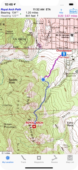
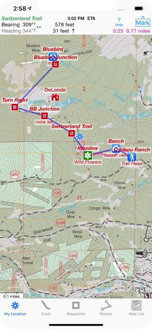
TRACKS, WAYPOINTS & ROUTES
Record a track as you walk, even in the background. View it on the map. Trip Timer & Odomete.r
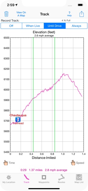
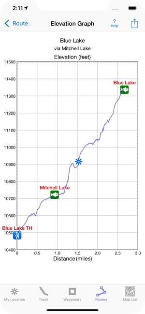
Show an elevation graph of your track or a route with altitude data. View date, time & average speed of track points. Measure the area inside a closed path.
Mark waypoints by their position on a topo map or a satellite map, by tapping a geotagged photo, by projecting from a known point or by searching place names. Refine a waypoint position when you arrive.
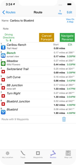
Set a quick GoTo waypoint or a full route & see the heading, direction, distance, elevation change & Estimated Time of Arrival at your destination & intermediate waypoints along the trail.
Create & edit routes using waypoints or recorded tracks.
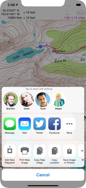
Export & Import GPX & KML waypoint, route & track files via eMail, Messages, Copy To, AirDrop, iCloud Drive, Dropbox or iTunes.
Import files using a custom URL scheme.
Send KML files to display immediately in Google Earth.
GPS+Glonass satellites & Barometric Pressure Sensor improve accuracy in challenging terrain & reduce elevation data noise on iPhone 6, iPad Air 2 & later.
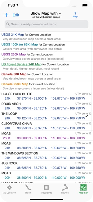
FOREVER-FREE TOPO MAPS
USA: Newest (2015) US Forest Service 24K maps.
USGS 24K classic maps for all 50 states, Guam, Puerto Rico & the US Virgin Islands.
USGS 250K & 100K (63K for Alaska) maps for all states.
Canada south of 54° latitude: National Resources Canada 50K maps for Alberta, British Columbia, New Brunswick, Nova Scotia & Prince Edward Island, and 18 Canadian National Parks.
Stitches beautiful richly detailed offline topographic map images for seamless coverage across map boundaries.
Includes map legends.
Store up to 750 maps to use in the wilderness without cell service. Maps from our server download faster & use less of your monthly data allotment.
Print & Share map images overlaid with waypoints, routes & tracks.
SET IT UP AS YOU LIKE
miles, nautical miles or km. ft or meters
Degrees, Degrees/Minutes, Degrees/Minutes/Seconds or UTM
°True or °Magnetic
HOW TOS
Tap Help in the App.
Online Manual on iHikeGPS.com
Twitter: @iHikeGPS
Email developer: [email protected]
WHAT OTHERS SAY
“I am VERY impressed!!!…It pretty much blows…, my previous fave GPS app, out of the water. Your track recording features, fast map downloads, and well thought out interface make it a real winner. It's very sophisticated software, and makes my iPhone just about as good as $600 Garmin… Actually better, in a lot of ways”-John in OR
“Perfect for anyone camping, fishing & hiking, it'll provide great detail when you need it the most…for anyone who takes the great outdoors seriously”-David on HandheldItems.com
“…thank you for developing IHIKE GPS…what a great product it is. I am impressed!…I use it hiking, biking, skiing & Jeeping”-Ammon in CO
DEVICE REQUIREMENTS
No device requires a cellular data plan to use iHikeGPS.
WiFi+cellular iPad 2 & later, and iPhone 4S & later support full navigation.
WiFi-only iPad 2 & later, and iPod touch (5th gen) & later require an iOS-compatible external GPS receiver to show your location in the wilderness & record tracks. View maps using the iOS device alone.
Continued use of GPS running in the background can dramatically decrease battery life.
Your dream of hiking adventures reaches new heights with iHikeGPS!
i Hike GPS : Topo Maps Guide
Unleash the navigation potential of your iPhone or iPad with iHikeGPS! Turn your device into a high-performance GPS receiver, equipped with USGS, US Forest Service & Canadian topo maps. These Classic topo map quads often have valuable back country details that vector maps in other hiking apps don't show.
Even in remote areas with no cell signal, iHikeGPS ensures you always know where you've been, where you are, and where you’re going. Experience the ultimate hiking companion, offering unparalleled track recording, route navigation & accurate Estimated Time of Arrival.
One Low Price! Everything included. No sign-ups, ads, subscriptions or in-app purchases. Completely respects your privacy.
Discover the limitless possibilities of iHikeGPS while hiking, backpacking, biking, canoeing, geocaching, camping, sightseeing, 4WD exploring & hunting. Recommended as the top choice in “Essential Gear for Safe Hiking”, it's a must-have for outdoor enthusiasts.
TRACKS, WAYPOINTS & ROUTES
Record tracks as you hike, even in the background. View them on the map with a Trip Timer & Odometer.
View elevation graphs of your tracks & routes. Show date, time, average speed and % grade. Measure the area inside a closed path.
Mark waypoints precisely using topo or satellite maps, place names or addresses, geotagged photos or by projecting from a known point.
Set a quick GoTo waypoint or a full route & see the heading, direction, distance, elevation change and Estimated Time of Arrival at your destination & intermediate waypoints along the trail.
Create customized routes using waypoints, recorded tracks, or imported GPX, KML or TCX files. Advanced route editing.
Send waypoint, route, track & map list files via AirDrop, eMail, Messages or iCloud Drive.
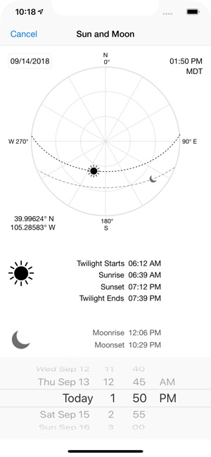
View the sun & moon position, rise times, & set times for any date & place on earth.
Send data to other apps such as Google Earth.
TOPO MAPS AT NO EXTRA COST
USA: Newest US Forest Service FSTopo 24K maps
USGS 24K maps for all 50 states, Guam, Puerto Rico & the US Virgin Islands
USGS 250K & 100K (63K for Alaska) maps for all states
Canada: National Resources Canada 50K maps for all areas south of 50° latitude. For Alberta, British Columbia & Newfoundland, coverage extends to 54° latitude.
Download using WiFi or cell service. Our maps are optimized to download faster & use less storage memory. Store up to 2200 maps to use in the wilderness without cell service.
These beautiful richly detailed offline topographic map images stitch together for seamless coverage across map boundaries.
Print & Share map images overlaid with waypoints, routes & tracks.
Measure distance and direction between any 2 points.
USE THE UNITS YOU PREFER
Miles, Nautical miles or Km
Feet or Meters
Degrees, Degrees/Minutes, Degrees/Minutes/Seconds, UTM or USNG-MGRS
°True or °Magnetic
HOW TOS
Comprehensive Help in the App
Online Manual on iHikeGPS.com
Email developer: [email protected]
WHAT OTHERS SAY
“I am VERY impressed!!!…It pretty much blows…, my previous fave GPS app, out of the water. Your track recording features, fast map downloads, and well thought out interface make it a real winner. It's very sophisticated software, and makes my iPhone just about as good as $600 Garmin… Actually better, in a lot of ways”-John in OR
“Perfect for anyone camping, fishing & hiking, it'll provide great detail when you need it the most…for anyone who takes the great outdoors seriously”-David's review
“thank you for developing IHIKE GPS…what a great product it is. I am impressed!…I use it hiking, biking, skiing & Jeeping”-Ammon in CO
DEVICE REQUIREMENTS
Use iHikeGPS on any iOS device even if you don't have a cellular data plan for it. iPhones & WiFi+cellular iPads support full navigation. WiFi-only iPads & iPod touch can view maps, but require an iOS-compatible external GPS receiver to show your location & record tracks.
Join thousands of satisfied users who rely on iHikeGPS for their outdoor adventures!
i Hike GPS : Topo Maps Information
Name i Hike GPS : Topo Maps
Category Navigation
Developer James Associates Inc.
Version 8.2.2
Update 2018-09-21
Languages English
Size 13.4 MB
Compatibility Requires iOS 9.3 or later. Compatible with iPhone, iPad, and iPod touch.
Other Original Version
i Hike GPS : Topo Maps Screenshot
Rating
Tap to Rate
Panda Helper
App Market


Latest News
Top Custom Software Development Companies for Startups in 2026 UX/UI Design Principles for Flutter Healthcare Apps: What Makes Patients Actually Use Your Product How to Protect Your Personal Data While Downloading Apps Looking for Z-library? Here’s the New Official Site Domain 8 Back Office Outsourcing Companies Helping Businesses Manage Daily Tasks How to Remove Background from Images Without Losing Quality